
- Monthly visits
- 0
- Pricing
- Not set
- Listed
- —
- Updated
- 2026-09-11
01What is ABot-Earth 0.7?
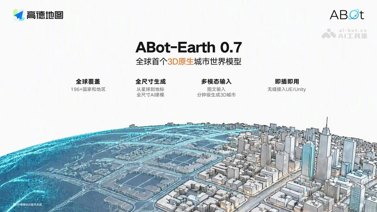
ABot-Earth 0.7, developed by Amap, is the world's first 3D-native urban world model. The model uses a 3D-native technical architecture and is trained on spatiotemporal data. Given a satellite image or a text prompt, it can generate a kilometer-scale 3D city on a consumer GPU in just 10 minutes. The model supports continuous generation at all scales, from planets to street views, covering 196+ countries and regions. Users can roam freely and interact in real time. ABot-Earth 0.7 has been deployed in Amap Flying Street View 2.0. As Amap's entry point for "spatial intelligence," it is evolving toward dynamic perception and spatiotemporal reasoning.
02Key Features of ABot-Earth 0.7
Image-to-3D / text-to-3D cities: Upload a satellite image or enter a text prompt to generate a kilometer-scale 3D city scene in 10 minutes.
Continuous generation at all scales: A single model seamlessly generates everything from planets to cities, street views, and landmarks, while spatial structure and visual appearance remain consistent as the viewpoint moves closer.
Free exploration and interaction: The model autonomously completes a fully continuous 3D space, enabling continuous entry, free roaming, and real-time interaction for an immersive sense of presence.
Plug and play: Generated results integrate seamlessly with UE/Unity for convenient developer integration.
Deployment in Flying Street View 2.0: Users can enter complex buildings and large scenic areas and roam through 3D scenes with a joystick.
03Technical Principles of ABot-Earth 0.7
3D-native architecture: The model is trained on spatiotemporal data containing spatial and temporal information, giving it an intrinsic understanding of 3D space.
End-to-end 3DGS generation: Outputs a 3D Gaussian splatting scene in a single pass, without step-by-step reconstruction.
Two-stage generation process: First generates a sparse structure (occupancy layout), then generates geometry and attributes (active voxel), progressively refining the result based on a satellite image.
Efficiency breakthrough: Produces a kilometer-scale scene on a consumer GPU in 10 minutes, approximately 1,000 times more efficiently than traditional approaches.
04How to Use ABot-Earth 0.7
Try it on the official website: Visit the ABot-Earth 0.7 official website at https://abot-earth.amap.com/ and register or log in to try it online.
Planet exploration: Open the planet page on the official website to freely browse the 3D spaces of Earth, the Moon, Mars, and generated cities.
Image-to-3D / text-to-3D: Upload a satellite image or enter a text description to generate a kilometer-scale 3D city scene.
Land Parcel Plaza: Browse and roam through 3D parcels shared by other users to experience the generation quality and roaming experience firsthand.
Use within Amap: Through "Flying Street View 2.0" in the Amap App, enter complex buildings and large scenic areas and control a joystick to roam through 3D scenes.
Engine integration (developers): Import generated 3DGS results directly into Unity / Unreal Engine, then add interaction logic for use in games, film and television, or digital-twin production.
05Core Advantages of ABot-Earth 0.7
World's first 3D-native architecture: Establishes an intrinsic understanding of 3D space from the ground up, representing a paradigm-level innovation in digital earth technology.
Extremely high generation efficiency: Generates a kilometer-scale 3D city on a consumer GPU in 10 minutes, approximately 1,000 times more efficiently than traditional approaches.
Continuous generation at all scales: A single model spans planets → cities → street-view landmarks, maintaining consistent structure and visual appearance as the view moves from a broad overview to fine details.
World-leading coverage: Its digital earth coverage includes 196+ countries and regions, the broadest coverage currently available.
Flexible interaction experience: Autonomously completes continuous 3D spaces for free roaming and real-time interaction, removing the fixed-route limitations of traditional street view.
Deep data advantage: Built on Amap's decade-long accumulation of spatiotemporal data, including nearly one trillion daily BeiDou positioning calls, with real-world samples that are difficult to replicate.
Plug-and-play ecosystem: Integrates seamlessly with UE/Unity and has been deployed in Amap Flying Street View 2.0, providing a complete path from user experience to commercialization.
06Application Scenarios for ABot-Earth 0.7
Smart mobility navigation: Enables 3D real-world navigation and destination previews in Amap and in-vehicle systems, allowing users to enter scenic areas, commercial districts, and complex buildings before departure.
Autonomous driving simulation and training: Quickly generates realistic kilometer-scale city scenes, providing low-cost, customizable simulation and testing environments for autonomous driving.
Game and film production: Generates 3D city assets in minutes and integrates them with UE/Unity, substantially reducing the cost of open-world games and virtual set creation for film and television.
Digital twins and smart cities: Builds an interactable 3D urban foundation for urban planning, traffic management, and emergency simulation and analysis.
Culture, tourism, and property showcases: Supports online 3D tours of scenic areas and museums, virtual property and scenery viewing, and spatial-perception training data for embodied robots and smart glasses.
© Disclaimer: domains and linked content may change over time. AIEZZ does not control third-party websites. Review external content and risks independently.
User reviews0